Stour Valley
  Search:
Location Map

Images of Dorset Galleries Isle of Portland Tyneham and Worbarrow Lulworth Marshwood Vale Moors Valley Badbury Rings Studland Bay Hengistbury Head Bournemouth Kingcombe Wimborne Blandford Forum Corfe Castle Wareham Bere Regis Poole Weymouth Chettle and Farnham Swanage Sturminster Marshall Melbury Abbas, Cann Shaftesbury The Caundles Gillingham Bridport West Bay Abbotsbury Shapwick Tarrant Valley Chapman's Pool Sherborne Upwey, Hardy's Monument Lyme Regis Wimborne St Giles Holt Heath Brownsea Island Kimmeridge Bay Ibberton Canford Heath Winterborne Stickland Bride Valley Osmington Chaldon Herring Puncknowle Christchurch Beaminster Holt Wood Cranborne Marnhull Sturminster Newton Moreton and Wool Arne and Middlebere Fleet and Langton Herring Ballard Down Hod Hill Hinton St Mary Evershot Dorchester Dancing Ledge Plush and Dorsetshire Gap Golden Cap Tolpuddle and Puddletown Fortuneswell Frampton and Bradford Peverell Cerne Abbas Pentridge Yetminster Powerstock
to view a photo gallery - click on a marker
Dorset in relation to UK

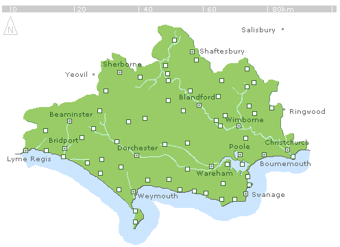
This sketch map of Dorset illustrates all locations that feature in a single subject gallery of photographs on the Images of Dorset site. To view the gallery associated with any selected location – click on the marker.

The map shows only those locations that have a complete gallery devoted to them - there are many more locations from around Dorset featured in photographs on this site – check out the Gazetteer for a full list.


square Picture on this page: Stour Valley, near Marnhull
top of page