
Search:
Badbury Rings
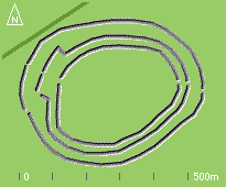
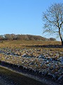
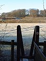
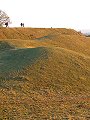
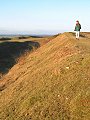
Located immediately to the north of Wimborne, Badbury Rings is an Iron Age hillfort that dates from about 150BC. The fort consists of three concentric banks and ditches, the ditches were excavated into the chalk along the outer edges of each bank. The sketch to the right shows the present day arrangement of the banks. The photographs shown here were taken over a number of frosty days, early in January.
The main entrance to the hillfort was from the south-west, a dog-leg in the middle bank blocking any straight-line approach to the gap in the inner bank. A smaller entrance is on the eastern side. The cuts in the outer and middle banks on the north-western side post date the original fort. The fortifications were no defence against the invading Roman army who – under the command of Vespasian – defeated the Durotriges and took control of the area in AD43.
The Rings were clearly of some significance to the Romans; Ackling Dyke – the road built by the Roman army to link Salisbury (Old Sarum, to the north-east) and Dorchester (to the south-west) passes directly by the Rings, making there the only significant change in its otherwise completely straight course. The dark green line on the sketch above shows the course of Ackling Dyke alongside the Rings.
|
|

|

|
|

|
|

|

|

|
|
To view any image full size - simply click on the thumbnail
| ||||
Badbury Rings are now cared for by the National Trust, and are managed as grass downland. A number of orchids have established themselves on the banks and nearby, the species distribution around the Rings reflecting the mirroring of slope and orientation of the banks on either side of the fort.
Find out more ... |
|
In the top row of pictures:
In the bottom row of pictures:
See also: Orchids at Badbury Rings Nearby locations that also feature in galleries on this site:
More views of Dorset in January Other sites on the webThe National Trust: Own and manage this site which is part of the Kingston Lacy estate, visitor information for Kingston Lacy and Badbury Rings The Iron Age: An excellent introduction to this period in the history of the British Isles, chapter 11 in Ron Wilcox's online texts on archaeology Maps of the area on streetmap.co.uk: 1:50,000 – detail, 1:250,000 – locality and route to get there
|