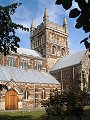
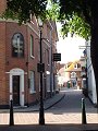
location where the photographs were taken
find out morefind out more

  Search:

Wimborne Minster

A small market town beside the River Stour, dominated by its large Minster church it has a long history. The Romans, on their way north and westwards into what would later become Wessex, set up camp on the opposite side of the river – at Lake Gates. 660 years later – c.705AD – Cuthburga, sister of Anglo-Saxon King Ine, founded a nunnery at Wimborne. This double monastery lasted some three centuries, until eventually being destroyed by the Danes.

The Minster church forming the focus of the town is largely of Norman origin – 12th and 13th century – the west tower is mid-15th century. Most of the town itself is Georgian, however there has been extensive growth of the surrounding suburbs during the last two centuries – mirroring the similarly rapid growth of nearby Poole and Bournemouth.


015-01 Wimborne Minster 015-02 Wimborne Minster 015-03 Wimborne Minster 015-04 Wimborne Minster 015-05 Wimborne Minster
015-06 Wimborne Minster 015-07 Wimborne Minster 015-08 Wimborne Minster 015-09 Wimborne Minster 015-10 Wimborne Minster
015-11 Wimborne Minster 015-12 Wimborne Minster 015-13 Wimborne Minster 015-14 Wimborne Minster 015-15 Wimborne Minster
To view any image full size - simply click on the thumbnail
  

Find out more ...

In the top row of pictures:

  • The Minster towers, seen looking westwards along East Street (picture)
  • High Street, the annual Folk Festival – a major entry in the yearly calendar of events (picture)
  • East tower of the Minster church (picture)
  • Detail from the Minster church, east tower and Saxon stair-turret (picture)
  • The Quarter Jack – high on the west tower – resembling a napoleonic figure, strikes the quarter-hour chimes (picture)

In the middle row of pictures:

  • High Street (picture)
  • West Street (picture)
  • West Borough (picture)
  • Church Street (picture)
  • Allendale House, c.1823 by Sir Jeffry Wyattville, the knight is recent – and often the target for adornment in various forms (picture)

In the bottom row of pictures:

  • Wimborne cricket ground, providing welcome open space near the town centre (picture)
  • 'Lewens' mid-17th century origin, altered and extended in the 18th century and later – one of the grander houses sited around the edges of the town centre (picture)
  • Chapel of St Margaret and St Anthony, chapel of a 13th century leper hospital, on the Blandford Road out of Wimborne (picture)
  • High Hall c.1670, altered in the 18th and 19th centuries – just one of many large mansions to be found dotted around the countryside surrounding Wimborne (picture)
  • The avenue of beech trees lining the Blandford Road west of the Kingston Lacy estate, a familiar sight to anyone travelling between Wimborne and Blandford (picture)

See also: Christmas lights

Other Wimborne galleries:

Nearby locations that also feature in galleries on this site:

directionBadbury Rings

directionHolt Forest, Holt Heath

directionPoole, Bournemouth, Canford Heath

directionSturminster Marshall, Shapwick


Other sites on the web

The Dorset Page:   Wimborne Minster – local information and links to further resources on the web

Maps of the area on streetmap.co.uk:   1:50,000 – detail, 1:250,000 – locality and route to get there

picture resolution
The pictures of Wimborne Minster in this gallery were captured at high resolution.
This is images of dorset stock photography gallery 015
All photographs copyright © 1998–2003 John Allen


top of page