Search:
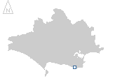
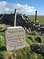
Chapman's Pool
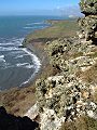
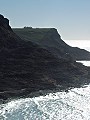
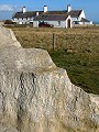
A walk along the coast from high on Houns-tout cliff (SY 951 772) past Chapman's Pool (SY 955 770) to St Aldhelm's Head (SY 962 753) in early-March. The coastline here erodes easily, the coastal path above Chapman's Pool has in parts begun to slide into the sea, necessitating the re-routing inland of this popular walk.
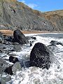
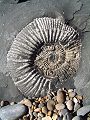
The soft grey shales and clays of the Kimmeridge beds are rich in fossils – particularly ammonites – but very susceptible to erosion and land-slip. The very friable nature of the rock means that the only method by which to 'collect' most fossils is with a camera, the slightest disturbance turning even apparently solid looking boulders into a heap of crumbling clay.
|
|
|
|
|
|
|
|
|
|
|
To view any image full size - simply click on the thumbnail
| ||||
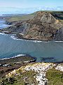
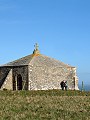
St Aldhelm's chapel, built in about the 12th century, sits squat – somewhat like a nomads tent – on the tip of this windswept promontory. Long since fallen into disuse, it was kept as a sea-mark by which sailors could navigate their way past this treacherous part of the coast. A lifeboat house with coastguard cottages nearby (nb atop this 108m cliff) attests to the extreme measures taken in response to the risks involved in sailing along this part of the Dorset coastline and to the enforcement of customs laws in centuries past.
Find out more ... |
|
In the top row of pictures:
In the bottom row of pictures:
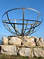
East of the Coastguard lookout (SY 961 754) there now stands a memorial built to commemorate more recent events in the history of this area. During the early Second World War years (1940–42) the promontory was used as a base for research into RADAR, much of modern telecommunications is derived from the work carried out here. See also: January 2002 for further pictures of the RADAR memorial and St Aldhelm's chapel Nearby locations that also feature in galleries on this site:
More views of Dorset in March Other sites on the webThe coastline shown here forms part of the Jurassic Coast World Heritage Site The Radar Pages: by Dick Barrett, lives up to his goal – 'All you ever wanted to know about British Air Defence Radar' West's Geology Field Guide to the Kimmeridge and Chapman's Pool area West's Geology Field Guide to the St. Aldhelm's Head area The Dorset Page: Worth Matravers – local information and links to further resources on the web Maps of the area on streetmap.co.uk: 1:50,000 – detail, 1:250,000 – locality and route to get there
|