Search:
Dancing Ledge and Purbeck Coast
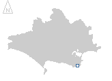
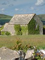
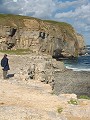
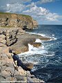
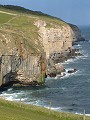
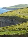
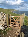
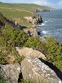
Dancing Ledge is a disused stone quarry, located right at the sea's edge on the Purbeck coast. The Purbeck stone extracted from this quarry would be loaded into barges brought in close to the cliffs at high tide, then shipped along the coast to the various destination ports. The photographs shown here follow a typical outing to the ledge, late on a showery day in early May. Starting at the small hamlet of Acton (SY 990 785) the route follows the Priest's Way briefly then descends southwards over the fields to Dancing Ledge (SY 998 769). The return route follows the coastal path westwards for a short distance, before ascending onto Purbeck once more to the village of Worth Matravers (SY 973 774).
|
|
|
|
|
|
|
|
|
|
|
To view any image full size - simply click on the thumbnail
| ||||
In 1786 the East Indiaman Halsewell was bound for Bengal when it foundered on the rocks at the foot of the cliff between Winspit (SY 976 761) and Seacombe (SY 984 766), many lives were lost. The Halsewell is just one of many hundred wrecks to be found along the Dorset coast, a number of which have been studied by marine archaeologists.
Find out more ... |
|
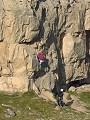
In the top row of pictures:
In the bottom row of pictures:
Worth Matravers and this section of the coast also feature in the monthly galleries October 2002 and April 2003 Nearby locations that also feature in galleries on this site:
More views of Dorset in May Other sites on the webThe coastline shown here forms part of the Jurassic Coast World Heritage Site The Nautical Archaeology Society: links to the Halsewell Archaeological Group and news about other archaeological work along the Dorset coast. West's Geology Field Guide to the St. Aldhelm's Head to Durlston Head area The Dorset Page: Langton Matravers – local information and links to further resources on the web Maps of the area on streetmap.co.uk: 1:50,000 – detail, 1:250,000 – locality and route to get there
|