Search:
Studland Bay
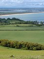
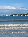
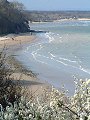
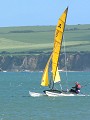
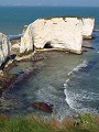
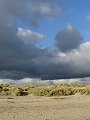
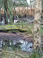
Studland – Forming the southern half of the entrance to Poole Harbour, it is an area of grass covered dunes, heath and scrub. At the harbour entrance is the small – aptly named – Shell Bay with about 1km of sandy beach. The shore-line continues southwards to the main beach – a broad stretch of sand some 3km in length, forming the western shore of Studland Bay. The southernmost end of the bay is marked by chalk cliffs leading to Handfast Point and Old Harry Rock (a chalk sea-stack) from where there is a gentle ascent onto Ballard Down.
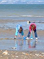
Both beaches draw large numbers of visitors in the summer months, Bournemouth and Poole being just a few miles away, but retain their appeal right into the depths of winter. The views presented here were taken out-of-season, during the months February–May and show just a few of the many reasons why this area is so popular all-year-round.
|
|
|
|
|
|
|

|
|
|
|
To view any image full size - simply click on the thumbnail
| ||||
Find out more ... |
|
In the top row of pictures:
In the bottom row of pictures:
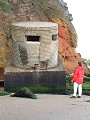
See also: Swanage to Sandbanks Nearby locations that also feature in galleries on this site: Other sites on the webThe National Trust: Own and manage this section of the coast, visitor information for Studland Bay – car parks, cafeterias, dog restrictions, etc. Fort Henry: wartime bunker used by King George VI, Prime Minister Winston Churchill and Generals Eisenhower and Montgomery to observe the live-fire practice on Studland Beach in preparation for the D-Day landings. This and other wartime relics at Studland have recently (April 2002) been restored and opened to the public. West's Geology Field Guide to Studland and the South Haven Peninsula The Dorset Page: Studland – local information and links to further resources on the web Maps of the area on streetmap.co.uk: 1:50,000 – detail, 1:250,000 – locality and route to get there
|