location where the photographs were taken
find out morefind out more

  Search:

Poole

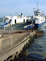
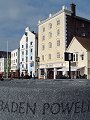
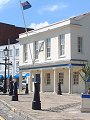
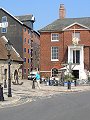
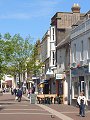
Poole's origins can be traced back to about the 13th century, when increased silting of the river at Wareham forced traders and fishermen to seek deeper berths in the main harbour. Poole soon became the largest port in Dorset – a title it still holds – reaching its zenith during the 17th and 18th century when it was one of the main ports of the Newfoundland trade. The growth of the leisure and tourism industries towards the end of the 20th century have brought about a revival in recent years.

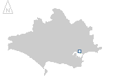
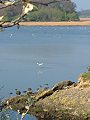
Poole Harbour – with its mouth at Sandbanks – is both one of the largest natural harbours in the world and an internationally important habitat for several species of migrating bird, with large areas of reed-beds and mudflats around its margins that are ideal feeding grounds for the large flocks of over-wintering birds that visit here each year.


023-01 Poole 023-02 Poole 023-03 Poole 023-04 Poole 023-05 Poole
023-06 Poole 023-07 Poole 023-08 Poole 023-09 Poole 023-10 Poole
023-11 Poole 023-12 Poole 023-13 Poole 023-14 Poole 023-15 Poole
To view any image full size - simply click on the thumbnail
  

Find out more ...

In the top row of pictures:

  • Poole's long maritime history is celebrated – alongside one of the main approach roads (picture)
  • Sandbanks – a stretch of golden sand ending in a small spit of land at the mouth of Poole harbour (picture)
  • The harbour mouth these days is unexpectedly narrow, a chain-ferry provides the service across (picture)
  • Most of the harbour is very shallow – raking for cockles at low tide (picture)
  • Poole's maritime links extend to being home to the Royal National Lifeboat Institute (picture)

In the middle row of pictures:

  • The Old Quay, with recent landscaping commemorating both Baden Powell and the role Poole played in the D-Day landings (picture)
  • The Old Quay – the Harbour Office – built in 1822 (picture)
  • The Old Quay – the Custom House, built c.1788 reconstructed in 1813 (picture)
  • High Street – Beech Hurst – built for Samuel Rolles in 1798 (picture)
  • Bowling Green Alley – on the edge of the conservation area, a reminder of the more workaday side to Poole's long history (picture)

In the bottom row of pictures:

  • The High Street, now largely pedestrianised ... (picture)
  • ... is also one of the busiest streets in Poole and leads up to ... (picture)
  • ... the three massive towers of Barclays House – they dominate the Poole skyline and can be seen from far around (picture)
  • A more recent and 'lighter' addition to Poole's very varied architecture – the Study Gallery at Poole Art College (picture)
  • And yet only a short way inland – along the heritage cycle route around Holes Bay – the natural habitat of the area is easily found (see also Arne) (picture)

See more of the Quay: French style street market

Nearby locations that also feature in galleries on this site:

directionCanford Heath, Wimborne

directionBournemouth

directionPoole Harbour, Brownsea Island, Studland Bay

directionArne, Wareham


Other sites on the web

Poole:   The official town website

Newfoundland Trade:   History of the Northern Cod Fishery (Canadian site)

The Dorset Page:   Poole – local information and links to further resources on the web

Maps of the area on streetmap.co.uk:   1:50,000 – detail, 1:250,000 – locality and route to get there

picture resolution
The pictures of Poole in this gallery were captured at high resolution.
This is images of dorset stock photography gallery 023
All photographs copyright © 1998–2003 John Allen


top of page