location where the photographs were taken
find out morefind out more

  Search:

Upwey, Hardy's Monument

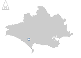
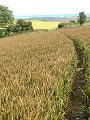
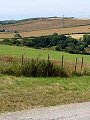
The photographs in this gallery trace the route of a 12km circular walk along the chalk and limestone ridges to the south-west of Dorchester. Taken in mid-July, a thick layer of cirrus covered the sky for most of the day as rain clouds built to the west, giving a flat and muted edge to the images. Starting in Upwey (SY 660 852) the path first climbs northwards onto Ridgeway Hill where it joins an inland portion of the Dorset Coast Path, from where there are views across to Maiden Castle (Iron Age hillfort) and beyond.


045-01 Upwey, Hardy's Monument 045-02 Upwey, Hardy's Monument 045-03 Upwey, Hardy's Monument 045-04 Upwey, Hardy's Monument 045-05 Upwey, Hardy's Monument
045-06 Upwey, Hardy's Monument 045-07 Upwey, Hardy's Monument 045-08 Upwey, Hardy's Monument 045-09 Upwey, Hardy's Monument 045-10 Upwey, Hardy's Monument
To view any image full size - simply click on the thumbnail

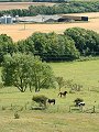
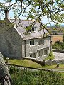
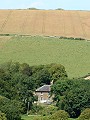
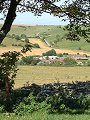
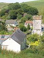
The route then follows the Coast Path westwards, passing a large number of tumuli – burial mounds dating back over 3000 years. Eventually reaching Hardy's Monument (SY 613 876) commemorating Admiral Sir Thomas Masterman Hardy, of Battle of Trafalgar fame. At this point the route turns south onto the limestone ridge above Portesham, then eastwards past Corton Farm and across Friar Waddon Hill before finally returning to Upwey.


Find out more ...

In the top row of pictures:

  • Ridge Hill (SY 653 866) looking north-eastwards, western half of Maiden Castle on the skyline (picture)
  • Further along Ridge Hill, wheat ripening – soon ready to harvest (picture)
  • Two of the many tumuli that stand prominent on the ridge line (SY 639 867) Hardy's monument in the distance (picture)
  • Monument to Thomas Masterman Hardy, paid for by public subscription, erected in 1844 (picture)
  • View from Corton Hill (SY 633 854) southwards over farmland (picture)

In the bottom row of pictures:

  • Corton Farm (SY 636 855) an old manor farm still retaining 16th and 17th century features (picture)
  • From Friar Waddon hill (SY 646 854) the view north-westwards back to Hardy's monument (picture)
  • And due north to Ridge Hill, with two further tumuli on the skyline (picture)
  • The upper reaches of Upwey, looking up Gould's Bottom (picture)
  • Upwey, and church of St Laurence (picture)

See also: Hardy's Monument at twilight

Nearby locations that also feature in galleries on this site:

directionFrampton and Bradford Peverell, Dorchester

directionOsmington

directionFleet and Langton Herring, Weymouth

directionBride Valley, Abbotsbury

More views of Dorset in July


Other sites on the web

The National Trustvisitor information for Hardy's Monument

The Dorset Page:   Upwey, Portesham – local information and links to further resources on the web

Maps of the area on streetmap.co.uk:   1:50,000 – detail, 1:250,000 – locality and route to get there

picture resolution
The pictures of Upwey, Hardy's Monument in this gallery were captured at high resolution.
This is images of dorset stock photography gallery 045
All photographs copyright © 1998–2003 John Allen


top of page