
Search:
Fleet and Langton Herring
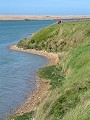
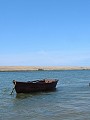
Stretching from Portland (7.5km to the south-east) to West Bay (20km to the north-west) is the large shingle bank known as Chesil Bank. Where it links the mainland to the Isle of Portland it forms a geographical feature termed a tombolo. Trapped behind the bank at its southern end is a semi-brackish lagoon of water – The Fleet – the largest tidal lagoon of its kind in the UK. Chesil and the Fleet are of international importance for both the wildlife to be found there and the geology of the area.

|
|

|
|

|

|

|

|
|

|
|
To view any image full size - simply click on the thumbnail
| ||||
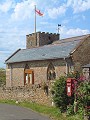
The pictures in this gallery follow a short circular walk starting at the small 'old' church at East Fleet. The chancel is all that remains of what was once a much larger church, most of which was washed away by a great storm in 1824 when the heavy seas broke through the bank. The path then follows the inner shore northwards, past Moonfleet Manor and along reed beds and tracts of marsh, all the time watched over by the row of coastguard cottages above Langton Hive Point. The route finally climbs a small hill to the village of Langton Herring, located just below the hilltop and sheltered from the coastal winds, before returning to the start point once more.
The lagoon and the small hamlet of East Fleet were the setting of J. Falkner's novel about Dorset smugglers – Moonfleet.
Find out more ... |
|
In the top row of pictures:
In the bottom row of pictures:
Nearby locations that also feature in galleries on this site:
More views of Dorset in May Other sites on the webThe coastline shown here forms part of the Jurassic Coast World Heritage Site West's Geology Field Guide to Chesil Beach The Dorset Page: Langton Herring – local information and links to further resources on the web Maps of the area on streetmap.co.uk (Fleet): 1:50,000 – detail, 1:250,000 – locality and route to get there Maps of the area on streetmap.co.uk (Langton Herring): 1:50,000 – detail, 1:250,000 – locality and route to get there
|