Search:
Fortuneswell
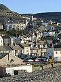
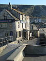
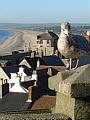
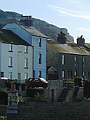
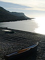
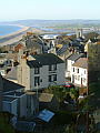
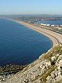
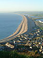
The Isle of Portland is a large sloping block of limestone, linked at its northern end to the mainland by a naturally formed gravel bank (a tombolo) known as Chesil Beach. The northern end is also the highest, with cliff-tops reaching 140m above sea level. Spreading upwards across this impressive and steeply sloping approach is the collection of districts that is Fortuneswell, lit here by the weak sun of a November afternoon.
|
|
|
|
|
|
|
|

|
|
|
To view any image full size - simply click on the thumbnail
| ||||
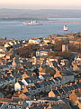
The character of the area is the result of centuries of quarrying and military occupation, leaving an industrial landscape that is relatively unique in Dorset. Whilst not attractive in the traditional sense, the landscape is none-the-less part of Dorset's heritage and is celebrated appropriately in the 'Spirit of Portland' sculpture situated high on the stone strewn slopes overlooking Fortuneswell.
Find out more ... |
|
In the top row of pictures:
In the bottom row of pictures:
See also: Fortuneswell in October Nearby locations that also feature in galleries on this site: More views of Dorset in November Other sites on the webThe coastline shown here forms part of the Jurassic Coast World Heritage Site West's Geology Field Guide to Chesil Beach The Dorset Page: Fortuneswell – local information and links to further resources on the web Maps of the area on streetmap.co.uk: 1:50,000 – detail, 1:250,000 – locality and route to get there
|